Much of the buzz about autonomous vehicles surrounds the technology needed to keep the car in its lane and from hitting other vehicles, or worse, pedestrians.
However, knowing where it’s going may be just as important so having up-to-date maps is critical the success of those vehicles.
Bosch and GPS-maker TomTom are pairing up to produce the highly detailed maps that will be needed for autonomous or semi-autonomous driving in the near future.
For those who thought navigation systems were already using these types of maps, think again. The two differ in the level of accuracy, which is now correct to the decimeter. The other difference is the layering of maps to create a comprehensive program.

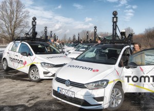
Bosch and TomTom have a fleet of vehicles conducting the surveys needed to produce highly detail maps for self-driving vehicles.
The traditional base navigation layer is used to calculate routes from A to B, including the sequence of roads to be driven. The localization layer uses a novel-positioning concept providing highly accurate map data, which the automated vehicle uses to accurately calculate its position within a lane.
(Apple hires former FCA quality chief. For more, Click Here.)
To do this, the vehicle compares its sensed environment with the corresponding information in the localization layer. In this way, the vehicle can accurately define its position relative to the road and its surroundings.
On top of the localization layer, the planning layer contains not only attributes such as lane divider types, traffic signs, speed limits, etc., but also 3D information about road geometry, including curves and slopes. With the help of this very detailed lane information, the automated vehicle can decide things such as when and how to change lane.
(Click Here for details about the best and worst places to speed.)
Think of the difference between current maps and the new autonomous-vehicle-friendly maps as the difference between the standard tube television and the new curved-screen 4K high-definition televisions. In fact, the maps are checked using the Tesla Model S and its hi-def, iPad-like touch screen.
The companies began the process in 2013 and are mapping all the roads in Germany to start. The program will be expanded to cover all of Europe and North America in the near future.
(To get a look at spy shots of the new Lincoln Continental, Click Here.)
“By the end of 2015, we want to have new high-precision maps for automated driving for all freeways and freeway-like roads in Germany,” said Jan Maarten de Vries, vice president, Automotive at TomTom.


The current maps and likely the new precision maps will suffer from a significant issue – that being geographic changes. Updates typically run 3-9 months behind actual changes in roads, thus the latest maps have hundreds if not thousands of errors in them as many GPS users can confirm. A human can adjust for such issues but how will an AV react when the road they think exist, does not?
In addition what will an AV do when it encounters a sink hole, overpass collapse, rude drivers cutting the nose off of the AV in a typical lane change? Will the AV do a panic stop, drive into the hole or under a falling bridge, tree, plane, etc.? it might sound far fetched but these issues all need to be addressed with AVs because the passengers have zero control over the vehicle other than maybe a panic stop button they may not want to hit when at highway speeds in heavy traffic.
BTW, my experience with TomTom, their maps and their GPS service interface means they are the LAST people on the planet that I would trust with ANY software. See their User’s Forums for a reality check.